FLORIDA
TO THE CARIBBEAN - THE DELIVERY SKIPPERS' ROUTE
©
2011/2014
Tor Pinney - All Rights Reserved
Ah, the
Lesser Antilles, irresistible as a Siren's song! Every year
these eastern Caribbean islands lure more and more sailors to
their sunny skies, steady trades, warm waters and white beaches.
However, those who heed the call face a long offshore passage
before the first island heaves into view. It may be useful to
review professional delivery skippers' boat preparation, route
planning and passage making techniques for the 1,100 nautical
mile, Miami-to-the-Virgins crossing.
Most yacht delivery and cruising sailboat skippers heading for
the Lesser Antilles from Florida or the US Gulf coast choose
Miami (or a little south of there) as their departure point. It
provides a better angle for crossing the Gulf Stream’s strong
current than Fort Lauderdale further north, while to the south
the Florida Keys curve away to the southwest, adding distance to
the transit.
Preparation
The first step toward accomplishing any goal is to make the
mental commitment to do it. If you want to sail to the Virgin
Islands and beyond this season, say so! Brag about it to your
friends. Set a departure date. Visualize the trip. Buy the
charts and guide books. Arrange to have your mail forwarded
there so you absolutely have to go. A determined attitude is a
prerequisite to completing any substantial voyage. This goes for
professionals and cruisers alike.
The next step is provisioning. Here's one instance where pros
and cruisers differ greatly in their requirements. For the
delivery crew, provisioning is simply a matter of loading up on
a few weeks worth of food, figuring on a 10-day average passage
and then doubling the amount to cover unexpected delays. But for
the cruising sailor who is heading down islands for the season,
the year, or longer, Florida is the last chance to really stock
up. Almost everything costs more in the West Indies, and many
things commonly found in Stateside stores aren't available at
all in the islands. Cram every locker, compartment and crevice
with non-perishable foods and supplies. You really can't have
too much aboard. Same goes for equipment, spares, tools, and
chemicals. Provisioning a cruising sailboat is a project that
ought to be completed before leaving the mainland. Fort
Lauderdale is an ideal place to do this, with many stores and
services that cater to yachts.
Finally, plan to carry plenty of fuel for the auxiliary engine.
You may wind up motoring for many days. Delivery skippers insist
on having at least a 500-mile motoring range for this trip, even
if this means carrying extra fuel jugs lashed on deck. They're
pros, not purists. If the wind won't give them a boat speed of 4
knots or better, the engine will.
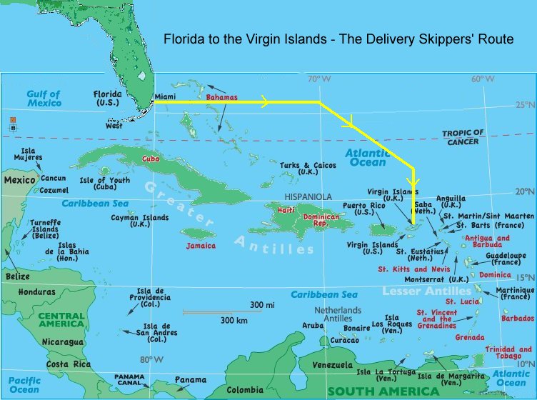
Route Planning
It's the
delivery captain's business to move a boat from point A to point
B as safely, directly, and quickly as possible. While the
cruising sailor isn't in such a hurry, there are some good
reasons to follow the pro's lead on this passage. If you glance
at a chart of the region, it appears that you could easily
island hop all the way from Miami to the Virgin Islands, with
the longest "offshore" leg being the 100 miles between Grand
Turk Island and Puerto Plata in the Dominican Republic. However,
this is deceptive. As you sail southeast through the Bahamas’
Exuma islands chain, you soon run head on into the trade winds.
In the fall these perennial winds blow most often from the ENE
thru ESE at 15 to 25 knots; sometimes harder. If you do beat
your way down to Puerto Plata on a hard port tack, you'll still
be facing nearly 350 nautical miles into the teeth of these
powerful winds and seas, a miserable prospect at best. Add to
that the knot or two of adverse current and you've got a long,
grueling journey that will test the resolve of the captain, the
loyalty of the crew, and the structural integrity of the vessel.
This is why the Bahamian port of Georgetown, Exuma (nicknamed
"Chicken Harbor") is crowded with Caribbean-bound boats that
won't make it the rest of the way this year.
Beating into the trade winds is the pits! Avoid it! If you want
to spent a winter cruising the Bahamas, that's fine. But if
you're intent on reaching the Lesser Antilles, follow the
delivery skippers' route offshore to the east.
Most boats make the passage from Miami to the Virgins in
November and December, right after hurricane season. The Pilot
Charts show us that the northern limit of the Northeast Trades
is roughly on the same latitude as Miami at that time of year.
Since the object is to avoid going east against the relentless
head winds likely to be encountered south of that latitude,
knowledgeable sailors head east from Miami, through the Bahamas,
and then continue due east or even a shade north of east into
the Atlantic. The idea is to make nearly all of your easting
north of the trade wind belt in the area of relative calm called
the Horse Latitudes.
Legend has it that the Horse Latitudes earned their name back in
the days when sailing ships carried live horses as cargo bound
for the New World. Sometimes becalmed for weeks in this region
of light and variable winds, the ship's crew would find
themselves running short of drinking water. Rather than share it
with the livestock, they'd jettison the unfortunate animals.
For today's auxiliary sailboat, the Horse Latitudes can provide
a relatively easy path to the east. This leg of the journey can,
however, require plenty of fuel (i.e., those extra jugs you
lashed on deck) and a healthy engine - or else the timely
arrival of a seasonal norther, but more on that soon.
How far east into the Atlantic should you go before cutting
southward toward the V.I.? Yacht delivery crews have debated
that question over many a cold Heineken in the watering holes of
St. Thomas. The trick is to enter the trade wind belt when
you're north - or just a little west of north - of St. Thomas.
That way the trades become your ally as you reach southward
across them on the home stretch to the islands.
You'll need a number of charts and guidebooks for this journey.
In addition to those covering the route and destination we're
discussing, you should also have charts aboard for the areas
along and to leeward of the planned route, in case you're forced
to make an unscheduled or emergency landfall.
A Final Check
When a delivery skipper takes command of a boat that he has
agreed to sail offshore, he's got to assure himself that it's
fit for sea in every respect. He becomes, in effect, a surveyor
and will spend hours or days checking out the equipment and
systems aboard before setting sail. The cruising sailor has the
advantage of greater familiarity with his vessel. Nevertheless,
glancing over the Delivery Captain's Check List (see sidebar)
may remind you of overlooked items.
All right, you're committed, provisioned and prepared in every
way. Last minute chores include cleaning the bottom, especially
the propeller, and stowing the dinghy. If you carry a dinghy on
deck, lash it you mean it, with chafe protection and lots of
strong lines cinched up tightly. Check the weather forecast for
late hurricanes and early cold fronts, treat the crew to one
last dinner ashore, file a float plan and ETA with some
responsible person, top off the fresh water and go!
The Passage
The first hurtle to overcome
on this passage is crossing the infamous Gulf Stream. Sailors
who know the Gulf Stream by reputation alone, fear it. Local
sailors respect it. In reality, for a seaworthy sailboat in
normal conditions crossing the Gulf Stream is no big deal. There
are, however, a few precautions that will ensure a smooth start
to your voyage.
Rule number one in the Gulf Stream is to avoid northers, the
cold fronts that come blasting down the Florida peninsula every
so often, usually beginning in November and becoming more
frequent and more powerful as the season progresses. A bit
further on, these wind shifts will become your ally, but when
strong northerly winds blow against the north-bound current of
the Gulf Stream, big, steep, breaking waves build rapidly,
making for a rough passage. If it blows really hard, the Stream
can become extremely dangerous for even the stoutest vessel.
There's no excuse for getting caught by a norther your first
night out. Just listen to a NOAA weather radio forecast on the
VHF before casting off. They'll report approaching cold fronts
at least 24 hours in advance. Internet and SSB weather services
like Chris Parker (http://mwxc.com/services.php) are also
excellent sources.
It's about 55 nautical miles across the Gulf Stream from Miami
to the Great Bahama Bank's northwest corner. Here the Great
Isaac lighthouse marks your first waypoint. When planning your
course, compensate for the 3 knot (midstream average)
northerly-setting current by steering about two points south of
the rhumb line. Work out current vectors based on your boat's
speed, allowing for the current’s gradual increase and then
decrease as you cross.
Most skippers make a night crossing of the Stream in order to
arrive on the other side with daylight. This does make the ship
traffic, which can be considerable near Miami, seem more
intimidating, but it will thin out soon after you get away from
the coast. For setting watches, three hours on and six off works
well with a three man crew. It not only allows enough rest, but
also rotates the watch schedule, giving each crew member his
fair share of sunrises at sea.
Great Isaac Light boasts a 23-mile visibility range. You’ll spot
it off the port bow before dawn and round it by sunrise. As you
approach, be sure it is bearing more than 60-degrees true. Any
less puts you in danger of the off-lying reefs. Give Great Isaac
a wide berth as you round it, at least a few miles. If the tide
is rising on the Banks it'll tend to sweep you in toward the
rocks at a knot or more.
For the next 65 miles, you'll be heading a point south of east
in Northwest Providence Channel, a 30- to 50-mile wide, deep
water pass through the northern Bahamas. It’s not unusual to see
some freighter traffic and the occasional cruise ship. After
dark you’ll spot Great Stirrup Cay’s 22-mile light and a
flashing red aero beacon, which you can pass fairly close in
deep water.
If you've been making decent time you'll cross Northeast
Providence Channel on your second night out. Ahead lies the open
Atlantic, but before heading into it you have the option of
stopping in Spanish Wells, Bahamas, near the northern tip of
Eleuthera Island. Spanish Wells is a prosperous community of
mostly white Bahamian fishermen and their families, descendents
of the original Loyalist settlers. Here you can replace any fuel
you burned en route from Miami, and top off the water tanks one
more time. Also, a little R&R ashore for the crew is a good
morale builder just prior to the offshore leg of your trip.
To enter Spanish Wells from Northeast Providence Channel, follow
the Bahamas guidebook instructions carefully. There is a
shortcut through the north reef, called Ridley Head Channel, but
requires local knowledge to enter. It can, however, be a handy
shortcut when leaving Spanish Wells in settled weather, with
good eyeball piloting skills and a bright, high sun.
Re-fueled and rested, it's onward to the Caribbean! Check the
weather forecast again. At this point experienced skippers are
hoping for a norther. Those same cold fronts that you were
avoiding just a couple of days ago in the Gulf Stream can now be
a real asset. The prevailing winds here are from the east and
southeast - exactly where you want to go (naturally), but as a
norther approaches it sets up a veering wind pattern. First the
wind shifts to the south, then southwest. Just ahead of the
front it may die in the west. Then the leading edge of the front
comes with a cold rush out of the northwest, usually accompanied
by blustery winds, clouds and rainsqualls. Then, as the sky
clears, the wind clocks around to the north and northeast before
settling back into the prevailing easterly again. Delivery
skippers, setting sail as soon as the wind goes south, use these
favorable wind directions to make a few hundred miles of "free
easting" into the Atlantic. Just be sure you're sails are reefed
way down before the arrival of the actual front. It can carry a
brief but powerful punch!
In the absence of a norther, the likely alternatives are beating
into steady easterlies, or motoring into light easterlies. If
the former, head out on the starboard tack to gain plenty of
distance from the leeward reefs and islands to the south, and
perhaps get north of the headwinds. If the latter, head due east
under power, feel the gentle rise and fall of the Atlantic
Ocean, and count your blessings.
For the next several hundred miles, you've got to resist the
temptation to head southeast toward the Virgin Islands. You
would soon find yourself beating into the trade winds with the
additional threat of dangerous reefs to leeward. Keep your
resolve to go east. It'll pay off.
As you're making easting in the Horse Latitudes, the Pilot Chart
indicates a couple of notable features. On the second day out of
Spanish Wells a current may set you 10 or 15 miles to the north.
Later, somewhere around 68-degrees west longitude (depending on
your latitude), you'll cross the San Juan-New York shipping
lane. Keep a sharp lookout here; there may be a lot of traffic.
Around 70-degrees west, start putting a bit of southing in your
course so that you cross the 24th parallel around the 67th
meridian. Then head roughly southeast by a point south toward a
waypoint of 22-degrees north and 65-degrees west. This meridian,
called "I-65" by some of the regulars, marks the last leg to the
V.I. and the best part of the trip. From here you sail due
south, soon picking up the Northeast Trades if you haven’t
already. The boat charges along with a bone in her teeth on an
easy reach. Man, what a sleigh ride!
You may see another sail on the horizon. Give `em a call on the
VHF and say hello! Keep an eye out for freighters, too. They
pass this way traveling between Europe and Panama.
As you approach the Virgin Islands from the north, a 1/2-knot
current will nudge the boat westward. Be careful not to
overcompensate. If you stray farther east than 64 30' W, you
risk sailing onto the infamous reefs of Anagada. They've claimed
countless unwary vessels over the centuries, and still manage to
snag the occasional yacht today.
Land Ho! If you find you're closing with the islands after dark,
don't risk entering at night. Heave-to and wait for dawn.
Accidents often occur at the very end of an offshore voyage when
the skipper is tired and overly anxious to get into port. Even
in daylight it's hard to tell which island is which at first.
They seem to overlap. A radar can help clarify things, but be
certain you have reliable position fixes.
If you’re heading for the U.S. Virgin Islands, leave Jost Van
Dyke to port and carry on to St. John, which is a nicer place to
clear in than St. Thomas. If you’re entering the British Virgin
Islands, sail around the east end of Jost Van Dyke and along its
south coast to make your landfall in Great Harbor. It’s the kind
of place you've been dreaming of. After clearing in with customs
and immigration, stroll down the white, palm-fringed beach to
Foxy's thatch-and-bamboo beach bar for a well deserved rum
punch. You and your crew have earned it!
Best of all, the whole Caribbean now lies waiting for you, one
harbor at a time! Welcome, Mon!
~
End ~
Back
to List of Tor's Tips